Showing posts with label Mission Creek. Show all posts

Sunday, April 20, 2014

"Ritual Objects" and Caution


Remember this? It's an artifact from Mission Spit salvage. We found two of them, and after agreeing that none of us has seen anything like it (and therefore could not pigeon-hole it), began speculating. In fact, I managed to convince myself it could be part of a ritual object, that we had somehow recovered two finials from a cross. Maybe the hundreds of sherds and shards didn't say anything more specific than "people here shopped at the Hudsons Bay store," but pieces of a cross brought by the Oblate Fathers of the Mission? Cool.

Of course, I knew this was speculation rather than science, and even though I tried my damnedest to find proof, asking the Oblate archives for images and scouring the web, to consider these parts of an actual ritual object rather than roosting them in the dingy pigeon-hole we know as "unidentified" would be a leap of faith. Great story, plausible even, but unproven.

So I told the story, with caveats, and held onto a kernel of hope that one day I'd find that proof. Maybe a third finial would pop up (or a fourth, if the bottom part had one as well), or a belated Oblate response indicating that yes, of course, all missions were issued with cast stone crosses. I was repeating this casual hope the other day as my daughters and I visited the beach once again.

And then, we saw one. Now, I had a trinity of possible ritual objects. One had eroded from a part of the beach slowly deflating as the engineered earthwork done during restoration settles into a natural repose. My kids knew this was exciting, and I told them, "This is so amazing. There should only be three, maybe four, of these things, and we've found three!" The only thing that could mess it up, I said would be to find a bunch more.

So yeah, there were a bunch more.

It took just a minute or two to find the second. Then in rapid succession, a third, fourth, fifth,...the crestfallen quickly lose count. All of them are like the original two, cast stone finials, broken at the base, exact same size and shape, out of the same mold. Worse yet, they were with other rubble, including some concrete test cylinders, basically the most recent material at Mission Spit, part of the rubble component dumped after the road was built. Some pieces (upper left in this shot) have tar and asphalt stuck to them.

Even though I did also find a couple pieces of 19th Century glass in the same area, the odds that these artifacts were dumped a century after the Mission have jumped way up. There's no certainty to the context. Given that asphalt and concrete were visible on the surface a year ago before the restoration project even occurred, these things could be just a few decades old.


But wait a minute. It was almost exactly a year ago when we removed the "Tenino Stone," a fountain that I've also posted about before. At the time, I found concrete test cylinders around and under this thing, which turns out to be one of three fountains for Priest Point Park made (and given to the city) by the Hercules Quarry of Tenino in 1915. The shot above shows the fountain and the rubble; based on the location of the shovel probe at the right of the shot, this is about where I found the finials, although it's hard to be certain in a re-sculpted landscape.

So maybe, the cast stone was a decorative element of the fountain, or some other early Priest Point Park feature. (There I go, speculating again.) Once again, I cast this idea to the net in hopes that, once again, someone will know more of the history, or recognize the artifact, or otherwise help me move from speculation to knowledge.

Thursday, March 13, 2014

Left Shoes Left Behind

A foot-long left foot's boot.

Among archaeologists, there is a tribe that will test the make-up of an artifact by tapping it against their teeth. Wood or bone or shell? Bark or rust or stone? Tap-tap-tap, and the sound will tell,...even for us older and deafer archaeologists, the difference in the vibration traveling up our teeth and into the maxilla and other cranial members yields a sense of what the material may be. Others are disgusted or afraid (and let's be honest, don't try this on a privy dig), but it can be effective.

Most of the time, the harder object, the sharper the sound, the better. Few objects of archaeological interest thump dully against enamel, because normally all that soft stuff rots away long before we arrive on the scene. The plink or ceramic or click of a lithic is welcome. Among the thunkier objects encountered by archaeologists are: deer poop, roots, rodent poop, crappy stone, goat poop, and wooden artifacts that once were beautiful, but are now just shapeless lumps.

At Mission Creek, though, and at many other places along the Salish Sea and its rivers, conditions conspire to preserve organics. Cool subterranean water flow keeps the ravages of oxidation at bay, and everything from pith to bark and bone to leather can remain fairly intact.

A "fairly intact" insole, once worn by a smaller left foot.

At the bottom of the dig at Mission Spit, we hit a layer of fart-smelling black goop, anaerobic and rich in organics. There were some pieces of cedar and cherry bark, as well as some worked timbers and bits of boots or shoes. As with the harder artifacts: a mix of native and foreign materials, a record of newcomers and persistence.

Interestingly, once into the layer of muck and organics, the ceramics and glass so common in the sandier sediment above disappeared. Shoes and axe-cut wood chips were plentiful enough to show that the Euro-American contingent had arrived, but as yet there were insufficient bottles and plates to become a noticable part of the archaeological record. On the other hand, shoes were dropping left and right (but mostly left, in this limited sample).

Other aspects of the site suggest that it dates to the Catholic Mission era, but may be the refuse of the associated Native community (not the Missionaries' house), and it's tempting to a curmudgeon like me to think that the wealth of shoes in the earliest level of the site signals a local rejection of introduced footwear. Were I a more political, post-modernist archaeologist, I might spin a tale of resistance from this trail of soles. But I am a simple man, who has noticed that shoes and boots tend to come loose in tidal mud, and it seems entirely likely that any number of shoes may have been lost by multiple nationalities stepping into or out of canoes and long boats at the spit where people landed when visiting the mission.

People never change

As if to prove that simple answers are best, on my last inspection of the Mission Creek outflow, I saw this Adidas sneaker, lost in a channel just a few months old.

Saturday, March 1, 2014

The View Through High Windows

Imagine if you will (and really, you must, for I have no photos this time), that you are looking out of an Olympia window in 1850. The view may be across the bay to a ship dropping anchor a under a magnificent sky, or it may be fog clinging or rain striking the pane just a couple of millimeters away. Either way, you would be one of the first people looking outside through a window in these parts.

More committed historians than I probably know which of the original hovels had a glass window, and in what year light first entered a building here through anything other than an open door or the space in the longhouse roof planks where smoke flowed out. Thanks to Mrs. George Blankenship, writing a pioneer history in 1914, I know that one early set of windows was in the school started by the Catholic Missionaries. Not the first windows in this neck of the woods, but probably the first ones through which daydreaming students gazed at the South Sound sky.

How would I know that they were looking at the sky? Because Mrs. Blankenship noted that the windows were high on the walls, supposedly to prevent the kids from becoming distracted. I went to school 3,000 miles away and more than a century later, but this same trick of scholastic architecture was in force: put the windows high enough that kids at desks can't see much.

How long before the miracle of never-melting ice or solidified air (or whatever the Salish mind made of the first pane) became the underwhelming reality of broken glass? My guess is: during construction. Not that that matters. Even if the school-makers and then the students managed never to break a single pane, eventually the school and all the other Mission structures fell and their windows broke (though probably not in that order, there being both boys and rocks in Olympia from early on).

If you are an archaeologist interested in the birth of a building more than its demise, those broken windows come in handy. Because it turns out that in some lucky parts of the globe, the typical thickness of a pane of glass changed systematically over time. In fact, one of the best known chronologies comes from Fort Vancouver (in WA, not BC), a Hudsons Bay Company outpost that got going before Olympia, and for a while the source of nearly all non-Native goods purchased through a secondary HBC outpost at Nisqually, almost certainly including any window glass purchased for the Mission.

What David and Jennifer Chance documented during their Vancouver study was that over time, glass thickness increased. A couple of years later, Karl Roenke made the case for a broader Pacific Northwest window glass chronology. These two schemes for turning precise measurements of pane thickness into a calendar agree for the most part, increasing confidence in this method, at least within the region.

Ideally, the archaeologist working with window glass (OK, the lab tech stuck making measurements for days) will have thousands of pieces. At Mission Spit, we got just 69 pieces. A small sample size is vulnerable to attenuation and probably other stat-talk weaknesses that I do not understand, but which can throw off results or make it hard to see a pattern.

In this case, though, the limited sample still sets the clock to right about where we would expect.  It turns out that 2/3 (n=46) of the sample falls entirely within the date ranges established by the Chances and Roenke that correspond to the Mission occupation (AD 1848-1860).* If you include the chronologies' AD 1855-1885 period, which overlaps with but is not entirely within the Mission period, then over 85% of the window glass is in the expected age range. The mean, median, and modal thickness of the Mission Spit collection all fall in the 1840-1860 range of the chronologies.Three pieces are too thin to appear on the chronologies, and 4 are too thick; these may be flat pieces of bottles, rather than window glass.


So what? We already knew that the Mission was active from 1848-1860, and the glass merely agrees. But stand on the other side of the pane and take a look. First of all, there's the distribution. The chart above gives counts per period for the Chance & Chance chronology. Most of the glass is at the early end of the spread, as would be expected of a new Mission. But there is also a dropoff at the late end of the scale as well--there's nothing to suggest that occupation continued after the Missionaries left, and after their caretaker gave up interest a couple of years later.

The archaeological implication is that the salvaged Mission Spit deposit, scooped up with heavy machinery and virtually no vertical control over excavation, does not appear to be mixed with post-Mission cultural materials. Along with a few other observations, the window glass chronology for the site helps increase our confidence that we are dealing with a Mission period deposit, and not generations of subsequent settlement.


* Strictly speaking, some of the glass appears to be older than the Mission, but none of the tribal oral history or other written histories indicate that a building with windows would have been present anywhere nearby prior to the Mission. Maybe HBC was still selling off inventory from a shipment a few years prior?

Thursday, February 13, 2014

And then...


Here's a sequence from before restoration of Mission Creek (September, 2013) and on through to after  the first King Tide after the restoration. In the shot above, they're pulling out some of the rubble dumped on the beach in the 20th Century. You can see the pipe, 3 feet in diameter, that was the outlet of Mission Creek for decades. See how the channel traces an lazy S on its way into Budd Inlet?


With the big chunks of concrete gone, this is what the channel looked like, not long after the first shot. Rubble removal has let the channel explore a bit (see the wetted ground insiude the lower curve of the S?), but not all that much has changed.


And here we see the effects of a rainy Fall weekend. There's enough outflow from that one little pipe to flood beyond the S-channel. Maybe this is why we found a log at the south edge of the channel, a check-dam to slow the flow and keep it from eating further south. Look at the mid-range left extreme of the whitewater, and you may notice the horizontal darkness that is that log.


And here above is the outflow in January, after the channel was dug (a few meters north of the old culvert), and then "armored" with cobbles. The photo was taken a bit to the right of the above shots, but you can probably pick out the S-curved outflow channel. The momentarily exhuberant leftward spillage has subdued, and the main flow (again, as all of these shots, at a not-extremely-low tide) is still following the S, more or leSS.


Over time, perhaps, more more than less. This is the lower elevation curve of the S. See how neatly it has undercut the mantle of cobbles introduced during restoration? See the unfortunate clams, exposed to the sun by a subtle nortward migration of said S? See the subtle layers of shell hash upon fine sediment? See the barnacles colonizing what is probably only a temporary mini-cliff? Some species are surprised and maybe killed by this movement, and others take advantage.

I have no idea whether the channel will continue its slow northward migration (but I hope not, because, damn, that's a pretty beach). 150 years ago, the channel was probably north of where it is now, but 150 years ago, the southern lobe of the estuary was not buried, there was not pavement nearby, the "city" of Olympia was a minor burg (capital or no), and the Eastbay Streams (Moxlie and Indian Creeks, in today's parlance) were not themselves culvertized. Maybe Mission Creek will impose itself upon its past and future channel, or maybe not. I intend to watch (and snap shots).

Friday, December 20, 2013

Anthropocene Beach


One more post about artifacts, and I'll be one of those writers who misses the forest for the trees. So here's one about dirt. Or sediment, if you insist.

So this post looks at the strata of the beach at Mission Creek. Before or after the restoration, one of the finest beaches of Olympia, shell and gravel laid out in crescents by tidal ebb and flow, the waves, and sometimes the wake of a boatload of fracking proppants coming in or of logs heading out. If you could zone out the occasional chunk of sidewalk from before or the artificial apron of cobbles flanking the stream outlet after, the beach looks natural.

But dip below the surface, as I did with hand auger and shovel when  looking for archaeology a few months back, and you get a different picture. For starters, a 4-inch bucket auger cannot get much more than a foot deep into the beach because you run into a layer of brick. Nor can a shovel get very far without expanding the hole and breaking your back hacking the bricks loose. Once through, what had been yellow clay gets very bluish-grey very quickly, the long-saturated gleyed layer that would make perfect sense back inland in the estuary, but which is a bit more baffling here. After a foot or so of that, you hit shell-gravel beach again.

Rip into it with heavy machinery, as happened when Mission Creek was restored this Fall, and the stratigraphy makes the depositional history that much clearer. The modern beach has been accumulating atop the slumping clay fill of the road that dammed the creek a couple or three generations ago. The yellow clay beneath the asphalt calved off and melted away over the years after the road was built, spreading itself thinner down the beach, taken by the very tides and waves that bring the gift of gravel, sand, and shell from the north (including quit a few Olympia Oyster shells, which  probably died decades ago in polluted Budd Inlet).

During the same time, someone used the road to dump bricks onto the beach. Lots of them lack any mortar, and quite a few are half-fired, mis-shapen, and brick-bat rejects, so I suspect that this may have been where some of the discards from a brick-yard up the hill came to rest. Some bricks also occur at the top of the yellow clay fill, just below the asphalt surface, so brick disposal in the area was not something that began years after the road was abandoned.

Lest you judge Olympians of yore, deploring their shore-dumping ways, allow that maybe they were just trying to cover the stinking grey mud that shows up right below. This clay is a little puzzling, since it is pretty pure and widespread both inland and seaward of the sand spit, but not beneath it. It could have been brought up from deeper when people dug out a path for the culvert that became the mouth of Mission Creek, but there does not seem to be enough mixing and disturbance. It looks like a natural estuarine deposit, but it's seaward of the spit, and post-dates the 1850s, perhaps by a lot. Maybe some smarter reader will explain this.


In any case, the grey clay is there, and just beneath it is the original beach. Which looks a hell of a lot like the modern beach, except there are even more oysters, and a greater shellfish diversity over all. This is where the mid-19th Century artifacts begin showing up.

And keep showing up, until you reach another, deeper, layer of gleyed cley. At which point, the channel excavation was deep enough for the project and excavation stopped; the hole was completely inundated anyway, so there was nothing more to see. Just before that point, though, the sand spit had a thin layer of red atop blacker, muckier beach; this looks like the oxidized surface (red) of a saturated, anaerobic (black) realm of the sand spit. Kept wet by fresh water seeping through from upstream and it's low elevation (higher than the lowest tide, but deep enough that evaporation's not a factor, and drainage of the matrix cannot beat the next tide flowing back in), this deposit contains bark, wood, and leather. Some of Olympia's earliest axe-cut wood-chips are here, as well as what may be the first generation of shoes lost (or tossed?) in the mud by children intent on being barefoot. Interestingly, this depth seems to lack any of the glass and ceramic that dominate the cultural component of the beach higher up; maybe folks just hadn't had time to break many bottles or dishes at that early date.

Whatever else the shoes and other artifacts may show, the stratigraphic history of Mission Creek tells a story. "Civilization," with its residue of shoe soles and broken glass, flowed onto the shores of Priest Point, and then ebbed. The Mission came and went, and while tribally produced stone tools and cooking rocks seem to have been part of this cultural deposit until occupation of this piece of earth ended. A road into the park covered the spit, people dumped bricks there, and other (or maybe the same) people stacked concrete rubble to keep the road from eroding away completely. Eventually, nobody cared about the road anymore, and it would collapse a bit now and then, while the currents and tides, waves and wakes, pushed new shell and gravel on top.

The "natural" beach of today is drifting in from the shoreline north of Mission Creek. Hidden beneath it is the flow and ebb of Western Civilization in the Pacific Northwest. Even with the road breached and the stream channel restored, it is unlikely that all the bricks will wash away, or all the clays and fills and alterations of modern humans will disappear entirely. Some day, geologists will come and see these Anthropocene deposits. Across the globe, wherever other (but innately similar) humans have altered waterways and dumped things, similar stories will enter the sedimentary record. Long after we are extinct, the stratigraphic sciences will find the evidence we left behind. 

Tuesday, November 19, 2013

Ritual Objects

A "ritual object;" the bottom is broken, so it used to be a bigger, more impressive object.


One of the oldest jokes among archeologists (which is saying something), is that any artifact that cannot be identified is a "ritual object." On the most comical fringes of the…uh, "discipline" is not the right word, I guess,…but at and beyond the edges of what most archaeologists would recognize as their field, "ritual objects" become more and more common. There is something of an inverse relationship between the frequency with which the "ritual object" is invoked and the seriousness with which any other archaeologist takes said invoker. Like radical diffusionism, it's a gateway concept to the "aliens made it," school of "thought."

But the nature of archaeology is that we often do find things that are mysterious. Amongst ourselves, after a quick glance around to see that no civilians or Mormonist archaeologists are in earshot, we'll hold up a mystery artifact and proclaim it a "ritual object." And then laugh, before talking about who we might show it to that will come up with a real explanation.

This happened a couple of weeks ago at the Mission Spit screening session. After a brief and wishful suggestion that it might be coral (and thus, possible evidence of Hawaiians at the Mission/Tribal settlement), all we could say about the above-pictured object was that it did not look like local stone, it lacked wear indicative of use as an abrader or other tool, and that none of us had ever seen one.

So it became a ritual object.

The gods of archaeology move in mysterious ways, and after cleaning and drying the artifact, staring at it at different hours and in various states of mind, it struck me (while in a drinking beer with other archaeologists state of mind) that maybe it really could be a ritual object. As in, part of a Christian cross. After all, it was found in a beach-load of Mission detritus. After a week of showing it around, reaching consensus that the material is artificial cast stone and that it appeared to be decorative rather than functional, after gingerly suggesting to other archaeologists that it could be an actual ritual object (and getting no laughs, much less a better interpretation), I was pretty well on my way to becoming convinced.

But I know me, and I know that I am a sucker for reflexive irony, or whatever it is when the joke interpretation turns out to be exactly right, and so I didn't really go public. Skepticism is one of the few bedrock tenets of my ad hoc religion.

Then, this past Saturday, in the last bit of sediment to be screened, another one popped up. Same material, same shape and size, even the same breakage pattern. Hmm. Somewhere in the sand that we did not screen, either in the other material that was dumped as fill somewhere, or just maybe still in the part of the spit that was not dug up, I think there is another piece, the end of the third tip atop a cross. Here is my clumsy hypothetical reconstruction:

Two of the cross-topping trinity accounted for.

So yeah, there are just two of the four tips accounted for, but hey, have some faith. If you recognize these as part of a cross, or if you can debunk that theory, please let me know.

Monday, October 21, 2013

Vikings Everywhere (the non-pillaging kind): Screening Weeks 2 and 3

Beneath the two archaeologist hats are, in fact, two archaeologists. The beer box is a trickster, though, containing only artifacts.
Two more weeks of screening have passed, and the pile has shrunk, thanks to a couple of Viking invasions. It turns out that professors at Portland State and Western Washington--Viking mascotted schools, both of 'em--are so dedicated that they'll spend a Saturday driving to Olympia so that their students can experience some hands-on archaeology. It also turns out that oldsters' fears are unfounded, seeing that a dozen or more college kids are willing to hit the road before 8AM to work,...for free, being sprayed with icy water for four hours, in cold damp weather, to find...broken glass. Along with the Vikings, there were Geoducks from Evergreen, and Clippers from South Puget Sound, even a, uh,..."Clans-woman" doesn't sound right, and that angry mustachio'd Scotty Dog McFogg is not recognizable to Americans, so let's just say a Simon Fraser grad student.

So instead of the half dozen committed geeks huddled over a few screens that I expected, there have been a couple dozen people for each of the last two weeks. Students working with their profs, with archaeologists both employed and avocational, people who have been doing this for a few years or a few decades sharing screens with the next generation. "Good eye...nope, just a rock...the middle of that rusty concretion looks like a mchine cut nail..." and eventually an "Oh wow!" that brings over people from other screens, or goes on tour with its finder. It's good for us old guys to work with people for whom this is all new. Questions keep us on our toes, and watching as eyes see things for the first time is rejuvenating.

I'd say more than half the pile has been sifted at this point, and the Wow finds and their more mundane companions are beginning to pile up. Everybody finds something, and even if any one piece of glass may not thrill, everyone is getting some experience in a pretty stress-free situation. No stratigraphy to interpret, no bulldozers idling at the edge of the pit, no obligation to write a report (except for me, I guess, but I have this feeling that  volunteers will emerge for that phase, too). Just spray, look, and pull out the artifacts. Even from quarter-inch screens, students and vets alike are coming up with small pieces, including things that could easily have passed through.

And the aggregated frags add up to data. The more there is, the more solid the report can be, the more likely we can say something and back it up. (Not that I'm against saying things with no evidence whatsoever; it's just nice to not always be winging it.) Also, as the numbers mount, so do the odds of finding the rarity that says something really interesting.

So I'm glad and grateful that the  hordes have appeared for two weeks running. Far from the stereotypical pillaging Vikings, they're contributing. At odds with the sleeping in after a night of riotous partying charicature of college students, they're learning and helping.

Wednesday, October 9, 2013

Mixed

The Mission Spit site failed to meet National Register of Historic Places eligibility criteria, the parameters for official "significance," because of a lack of integrity. Specifically, in archaeocratic reasoning, there are two weaknesses to the site, if you are looking at it as a collection of archaeological data. One is that it is a beach deposit instead of the remains of a structure or primary deposit associated with the mission; its stuff that was tossed toward water, moved around by freshets, waves, and tides, rather than things that were stashed, cached, or dropped into corners or through floor boards, The second is that when I did the shovel probes and test unit, there was no correspondence between depth and age. The oldest types of glass showed up from the top of the deposit to the bottom, and same for the newest.

The second conclusion, the lack of a Deeper = Older stratigraphy, may have been reinforced by the presence of a few "pre-Contact" materials, things like fire-cracked rock and an arrowhead that are generally interpreted as evidence of use prior to the arrival of Euro-Americans or Asians. The assumption underlying this conclusion, that traditional indigenouse technologies were abandoned as soon as foreign ones showed up, has been something that drove me nuts over the years both here and in Hawai`i where I used to work. Maybe the arrowhead was washed in from a midden site up the coast, or maybe it was still cheaper than bullets in 1850 (much less a few years later, when tribal people interested in ammo were greeted with a higher level of suspicion), or maybe it was a memento or ornament. And while copper pots were available at Fort Nisqually, and the local French priests may have come equipped with tureens, it's hard for me to imagine that the Native people quickly and completely abandoned the utility of fire-heated rocks.

So maybe the "pre-Contact" artifacts are in fact "Contact." Salish technologies that persisted. Archival evidence indicates that the northern edge of the Catholic Mission was where the orchards, garden, school for Native kids, and associated Native parents's settlement occured. Squaxin Tribe oral history says that somewhere at Priest Point, Tribal people were interned before their removal to their island reservation in 1860. While drift cell movement of an up-coast midden deposit or mixing of shallow and deep beach sediments are plausible explanations for the presence of traditional artifacts along with historically introduced ones, it seems simpler given then history of the place to interpret this mixing as evidence of a Contact era site. If the historic artifacts in the cultural layer fall between 1848-1880, then maybe the fire-cracked rock and lithics do as well.

Which brings me to this photo, which is just what I was hoping this salvage effort would reveal:


Two scrapers. Or at least that's my interpretation, upon which I will expound: The bottom edges are beveled, with tiny flakes indicative of use wear along the blade. They're about the same size, both triangular, and to my sinsetral dismay they both seem to fit a right-handed grip best. But the left one is made of an alcohol bottle, and the right one of stone. Not local stone, unless it was a lucky find in a glacial gravel deposit, and therefore not necessarily easy to replace.

But then these French guys show up, drinking from vessels made of what seems to be some kind of obsidian, the stone that grand-dad used to talk about, available only in a land weeks away to the south. And the foreigners just toss it when they're done. Nice raw material for scrapers, maybe arrowheads and knives too, but we haven't found those...yet.

Tuesday, October 8, 2013

Screening Party #1 (or, Underground Archaeology Month Kicks Off, Above Ground)


Last Saturday, ten people got together to begin screening 10 cubic yards of sediment from the Mission Spit site. Most of us are professional archaeologists, and the avocational crowd included people who have worked on sites ranging from nearby Fort Nisqually to a bastle in England. Working with people who bring such knowledge to the screening table was nice, and even better is the fact they were willing to give up a big chunk of a pretty Saturday. Thanks!

We had enough hoses and screens to keep everyone busy, and we made defintite progress. But what some of us thought looked like a not-so-big pile at the beginning of the day turned out to be actually-pretty-big at the end of the day. On the other hand, the crew worked hard, and most will be back next week. Rumor has it that there will be more help this coming Saturday, when weather may again be decent. Even if it rains, as someone pointed out, it only helps with wet screening. Speaking of which, I love wet screening--with the dirt washed away, even the tiniest artifacts reveal themselves, and since we had incredible water pressure, there was not much need for shaking the screens (which is easier on delicate artifacts and old backs).


We began the day working on a part of the pile that had more clay overburden and fewer artifacts than I'd seen during testing at the site, but we did find some good stuff. Sherds and shards, mostly, some of them nicely diagnostic, a couple or three beads (two glass, one dentalium), as well as fire-cracked rocks, a few lithics, and a few fragments of deer bone. Sounds like the mixed deposit we expected, but I'll come back to the issue of just how mixed in a later post.

I'm very grateful that people showed up to try and glean something from this site, and look forward to a few more rounds of this work. We may not change history, but we're keeping a little of it from being dumped, unexamined, as fill. There's no contract, no grant, not even an organization. Just a swarm of interested people. It's happening during Archaeology Month, but it wasn't planned as part of it (I'd say it is Underground Archaeology Month, but the pile is totally on top of the ground).

OK. Gotta run, but I'll keep posting if people keep reading.


Tuesday, October 1, 2013

At Mission Creek, Even the Fill is Interesting


The Tenino Stone, with a stealthy concrete base.

Last Fall, I came across something that other people have probably seen for years, and others have forgotten about for even longer, but it was new and mysteriouis to me. Embedded in an old road berm on the Eastbay shore was a big piece of carved sandstone. Recently, I was around as a city crew pulled it free as they prepare for an environmental restoration project. In decades of archaeologizing, this stands out as one of the biggest and most interesting artifacts I've seen. It also holds a few mysteries.

Now that I've had the chance to look at it a few times, see the dirt it came out of, and talk it over with a few other archaeologists as we examined it, a few things are not so mysterious. Like, it was pretty obviously just dumped here along with concrete, asphalt, and brick rubble, part of the berm that blocked the mouth of a creek; a neighbor thinks the Salmon Club may have been involved, but it is also in a City park, at the bottom of an old road, and may have been deposited by them. I'll get to why I think that may be the case in a bit.

The stone is sandstone, and a partially obliterated inscription on one end is enough to convince me that it came from the Hercules Quarry in Tenino. The top features a square flanked by two octagonal basins, and a tunnel runs through it. There is rust surrounding one side of the opening, indicating that there was a metal attachment there, and along with pipes running from bottom to top, it suggests that this may have been a decorative fountain. The base, beginning immediately below the tunnel through the stone, at first appeared to be sandstones as well, but turns out to be stucco over concrete. The very bottom is unadorned concrete that contains glacial pebbles and bits of shell, more what you'd expect of a locally-mixed batch than what comes from commercial suppliers. More specifically, what you'd expect from a shoreline local batch than Tenino. (Ironically, the development of commercial concrete businesses is what did in the Hercules and other quarries in Tenino.)
The top.
And that's about it for what I know. A once fancy piece of stonework, stripped of metalwork and dumped on the Olympia shoreline. Maybe a fountain, and if my interpretation of the inscription (shown below, after considerable computer enhancement) is correct, it was a presentation piece. It just so happens that the abandoned road heading uphill from this spot leads to the former location of the "Swiss Chalet" that stood in Priest Point Park from not long after it's 1905 founding until the 1950s. Before that, the Chalet had been part of Olympia Brewing Company's pavilion at the Lewis and Clark Expo in Portland. A nicely carved fountain proclaiming a presentation and naming the quarry seems like just the sort of thing that may have appeared in that sort of setting, especially since Olympia Brewing even in those days was stating, "It's the Water."

Or, maybe the Hercules folks presented it to the park. Or, something else. Some sort of Park connection makes sense, though, given the proximity (seems like an awful big stretch to say that some Tenino resident hauled it all the way up here to dump it), and the fact that you need heavy machinery just to move the thing.

"PRESENTED BY HERCULES QUARRY, TENINO WASH" (Guesswork in grey).
Odds are, this modestly monumental stonework, dumped and forgotten for years, is likely to be recycled by the City of Olympia. Maybe placed in the park, or maybe elsewhere, but people once again see it as something interesting, worth using for some better purpose than shoreline armoring. Maybe it could be fixed up and one of Olympia's artesian wells could bubble forth from it.

In the meantime, if anyone out there knows about this, or has photos of the chalet in Portland or in our park, leave a comment and let me know. If I find out anything, I'll write an update. 

Mission Creek Salvage Project

There's a heck of a nice spit under that clay (or there was, anyway).


At long last, the Mission Creek salvage project is ready to go. About 10 cubic yards of Eastbay beach was delivered to a place where we can screen it at leisure, with a water hook-up so we can spray the fine stuff through the screens and pull the good stuff from them.

The source is a sand spit near the mouth of Mission Creek. Although there are artifacts within it, the stratigraphy left something to be desired, so the site is not eligible to the National Register. No data recovery is required, but that does not stop the data from existing, and local archaeologists are stepping in to recover what we can.

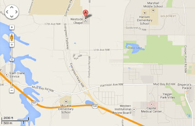
Screening will happen every Saturday in October, 10:00 - 2:00 (as with most archaeological time, this comes with a +/- factor, to be determined by when people want to work). The location is the west Olympia location of Saint Michael Parish. 1835 Overhulse Road, Olympia WA if you want to get yourself an internet map, which will look something like this:


If you are an archaeologist interested in participating, but have not gotten on the email list, comment below, and I'll get back to you. There is room for a limited number of non-archaeologists as well, especially if you have some experience.

Besides having running water for screening, we'll have access to bathrooms and a kitchen, so you can have a hot lunch if you want it, and change into dry clothes at the end of the day.

Thanks,
Maurice